Walking through Water with a Hydrologist
- Blog Post
- Exhibitions

Cerro Prieto Geothermal Power Station, Baja, Mexico, 2012. Edward Burtynsky (Canadian, b. 1955). Digital chromogenic print on paper; 121.9 x 162.6 cm. New Orleans Museum of Art, Gift of the artist, 2016.46.22. © Edward Burtynsky, courtesy Weinstein Hammons Gallery, Minneapolis / Nicholas Metivier Gallery, Toronto

Water: Edward Burtynsky, on view at the Cleveland Museum of Art through Sunday, September 22, explores humanity’s increasingly stressed relationship with water — the world’s most vital natural resource — through 13 monumental color photographs. In the essay below, Barbara Tannenbaum, chair of prints, drawings, and photographs and curator of photography, discusses these photographs and the environmental issues they document with Dr. Donald Palmer, professor emeritus at Kent State University and a specialist in hydrology.
The monumental color photographs in Water: Edward Burtynsky are stunning. From a distance, they could be mistaken for abstract paintings. But they’re not. They address real-life, factual, and highly specific situations about humans’ management of water resources. To understand the images fully, one must not just appreciate the aesthetics but also begin to understand the environmental issues they document. My training is in art history, not geology, so I called up Dr. Donald Palmer, professor emeritus at Kent State University. He generously spent an hour looking at the exhibition with me. Dr. Palmer is a specialist in hydrology, the branch of geology that studies the properties of water and its movement in relation to land. I walked away with a deeper understanding of some of the images and of how those sites relate to the water-management issues most relevant to northeast Ohio.
We began by discussing the electric blue Cerro Prieto Geothermal Power Station, Baja, Mexico, 2012.

Ostensibly a clean source of energy, geothermal power that draws superheated water from deep underground comes with risks. The hot water contains elements dissolved in it — at Cerro Prieto, lithium and potassium salts — that in high concentrations can have negative impacts on human health and the environment. In the 1980s Dr. Palmer helped research how geothermal energy might be employed in Ohio. We wouldn’t use it to generate electricity but instead to save energy. Using groundwater, which remains at a steady 55 degrees year-round, can more efficiently heat and cool buildings than outside-temperature air. This type of geothermal system doesn’t run the same pollution risks as the one at Cerro Prieto, but the equipment proved to be expensive and thus not competitive in a market with relatively low energy costs.
We next turned to Oil Spill #10, Oil Slick, Gulf of Mexico, USA, 2010, which shows the ecological disaster resulting from the 2010 blowout of the Deepwater Horizon offshore drilling rig (also known as the BP oil spill).

In the image, the spill doesn’t look too bad. That’s Burtynsky’s point: that the dispersants used to break up the oil pushed it below the surface, hiding the true extent of the spill from cameras. I learned from Dr. Palmer that the raw petroleum that spewed out of the drilling rig would have eventually degraded, oxidized, and sunk to the bottom of the sea on its own. The dispersants that were added to “remedy” the spill harm the water and ecosystem and last longer than raw petroleum.
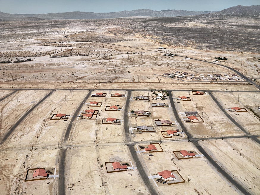
Moving from the ocean to the desert, we crossed the gallery to look at Salton City, California, USA, 2009.

Dr. Palmer pointed out that Salton City is a prime example of the 1950s push to develop the Great American Desert. During that decade, the town became a busy resort offering lakeside lots, swimming, waterskiing, fishing, and boating, all thanks to the Salton Sea. It was formed accidentally in 1905 when the Colorado River breached its levees and flooded a desert valley for two years, creating California’s largest lake in one of the driest places in the United States. With almost no annual rainfall and infiltration by pesticides from nearby agriculture, the lake evaporated, shrank, and became 25 percent saltier than seawater. Needless to say, it is no longer such a desirable vacation destination.
Just across the gallery is an additional example, Pivot Irrigation / Suburb, South of Yuma, Arizona, USA, 2011, which shows how people are building cities and suburbs in what was once called the desert but has been rebranded as the Sun Belt.

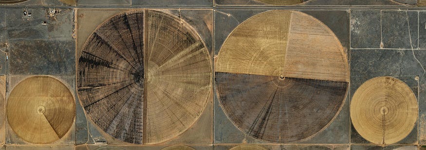
That image and Pivot Irrigation #7, High Plains, Texas Panhandle, USA, 2011, depict pivot irrigation — farming in areas with almost no rainfall.

Pivot irrigation requires that each circular crop area has a centralized well with a pump that draws from an aquifer. Dr. Palmer remembered talking with a driller in California who was usually called back to a site in about seven years to dig the well deeper, then again deeper, and deeper, going 700, 800, and even 1,000 feet deep to reach water. These aquifers contain fossil water — amassed over a few million years — which is a nonrenewable resource, Dr. Palmer pointed out.
Dr. Palmer offered a far less drastic prognosis for the North Coast. Ohio is rich in water resources, and we usually get enough rain to replenish the water table. This year, many of us would be happy to not see rain for quite a while, but perhaps the images of Salton City and Yuma will help us appreciate its benefits. Our water problems are different than those depicted in these images of other parts of the United States and the world. They stem mostly from pollutants getting into our rivers, lakes, and groundwater. The culprits? Industrial wastes, agricultural chemicals such as pesticides and fertilizers, and acid drainage from old coal mines in the state’s eastern and southern areas. If we can continue to improve the health of our rivers and lakes, and don’t allow the Great Lakes’ water to be pumped to other regions, Ohio should be able to continue to offer ample water for drinking, recreation, agriculture, and even transportation — although ideally in the form of a person-powered canoe.
Water: Edward Burtynsky is on view through September 22, 2019, in the Mark Schwartz and Bettina Katz Photography Gallery.
Water: Edward Burtynsky is organized by the New Orleans Museum of Art.